RE OnSite provides smart and cost-saving inspections and guarantees the quality of the collected information.
Agreements from traditional and performance contracts are easily traceable. Information from the inspection is immediately sent and processed digitally. Paper-based documentation is no longer necessary, which means that the processes are more streamlined. Relevant employees and cooperation partners can immediately start using the information.
Exchanging information in various forms (directly or via documents) is easy with RE OnSite. This makes processes measurable. Practice has now shown that a lot of work is saved and quality is improved. Ultimately, this leads to significant cost savings! The app is part of the RE Suite of DEMO Consultants.
GIS functionality
RE OnSite has extensive GIS functionality that can be used with different map sources and forms, such as Apple Maps, Open Streetmap, Google, TomTom and ESRI maps. This makes it easy to find the locations of the various objects and to reach them quickly. Moreover, there is no misunderstanding about the location of an asset; everything is accurately recorded.
Building and Infrastructure Inspection Modules
The RE OnSite app currently has 4 different modules. With the survey module, checklists can be compiled for various purposes. In addition, there are specific modules for Maintenance (NEN2767), Visual Quality (CROW) and Supervision (management).
Below you find a brief description of the modules and their application.
OnSite Maintenance
Condition assessment and fire safety inspection on location
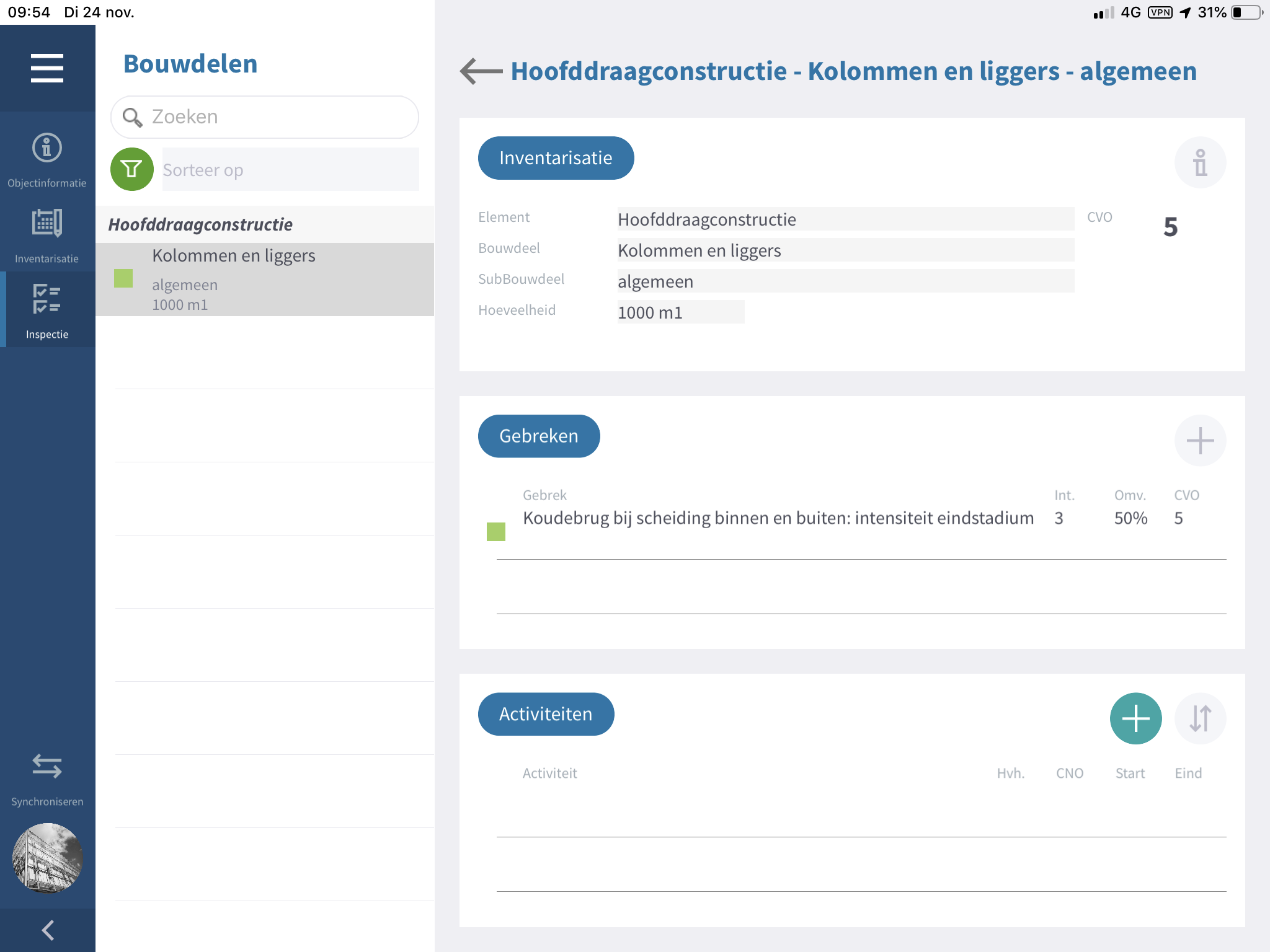
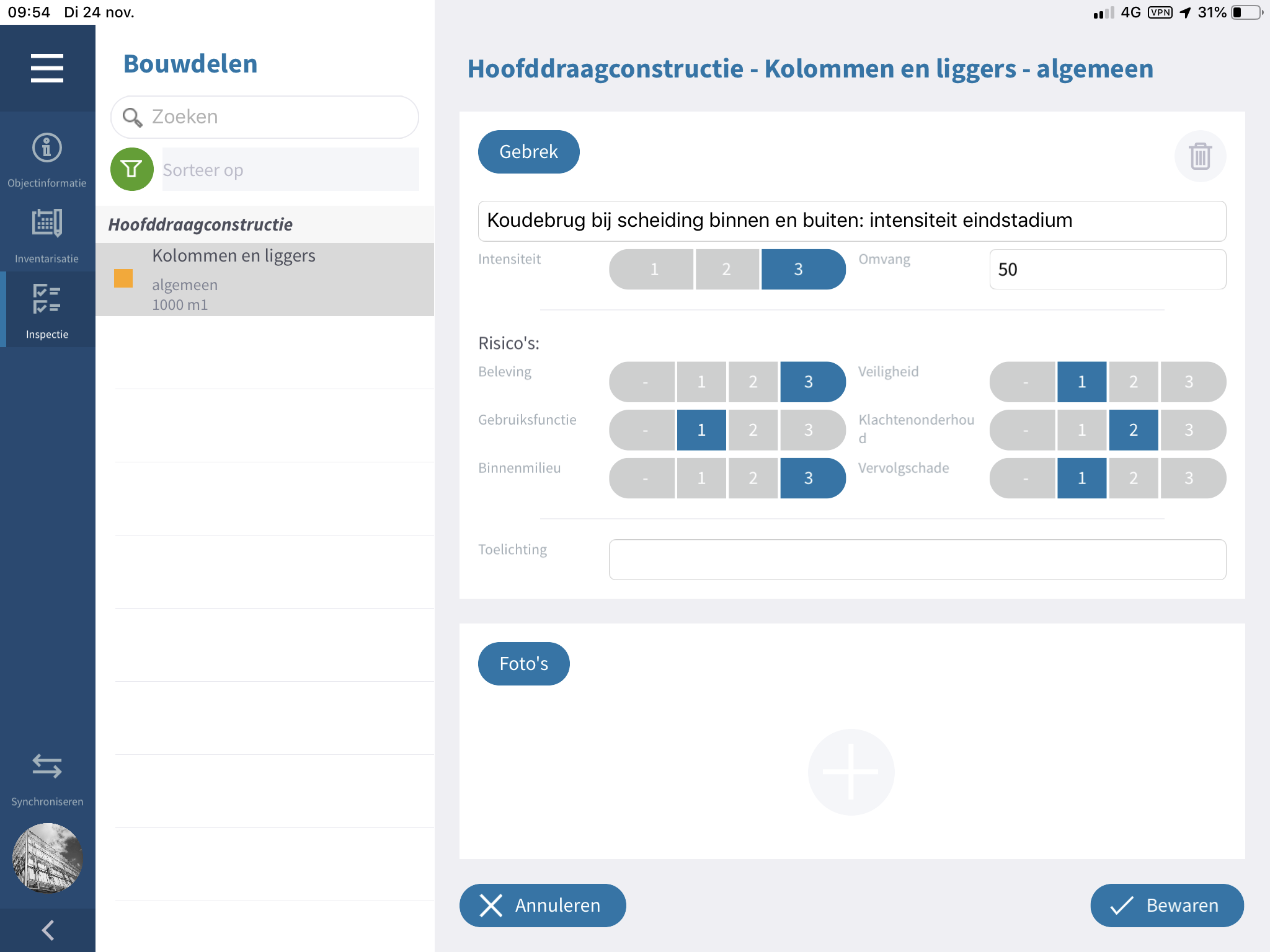
This module makes building inspection much more efficient as inspection data and photos are entered and synchronized on site. The building components that are linked in the RE Suite are ready here for on-site inspection. Color coding makes it clear which inspections have already been carried out and which still need to be done. The checklists can be compiled and made available to relevant users, allowing different types of inspections to be carried out. The integration of BIM models is also possible.
OnSite Visual quality
Infrastructure management and inspection based on image quality (CROW)
The inspection of assets such as roads and street furniture in (public) outdoor areas becomes fast and efficient with the Visual Quality module of RE OnSite. The assets are linked in RE Assetmanagement and are ready here for on-site inspection, either scheduled by the inspector or via the sampling module. Organizations that work with performance contracts have insights into the inspection data as well as their contractors. This module is also successfully used for more traditional maintenance contracts. This prevents many misunderstandings and therefore errors and loss of time.
OnSite Supervision
Management and supervision on location
This module allows better and safer supervision of construction and renovation projects. It forms a good basis for communication between client and contractor. Quality is carefully checked and documented by means of test plans based on the contract and specification documents. Functionalities such as sampling, ad hoc testing, EXIF photos, GPS coordinates and reports make monitoring work more complete and faster.
OnSite Survey (Checklist Inspection)
With Survey, a user can compose questionnaires themselves depending on the purpose of the inspection, such as a fire scan or risk analysis, but also maintenance, renovation options and Smart readiness (SRI) of a building, etc.
The most important benefits
- Integration of BIM models
- GIS functionality (including ESRI)
- Compile and enter checklists by yourself
- Photos with EXIF information of building parts and defects
- The photos can be provided with notes and sketches on-site
- Easily link locations to building components/questions
- Easy to display and consult all relevant information and documentation such as contracts and drawings on-site
- Can also be used offline
- Clear and intuitive user interface
- Logical and handy input screens, so that serious time savings can be achieved during the inspection
- Ability to record texts with the app typing it out for you (useful for hazardous locations)
- Inspection data synchronization with RE Suite
- Automatic detection of relevant assets and components
- QR code recognition
Inspect with RE OnSite
In the video below you could see how an inspection with RE OnSite works.
Case Port of Rotterdam 
The Asset Management Infrastructure department of the Port of Rotterdam Authority has been working with the RE Suite since 2011. The RE Suite is used for inspections, performance monitoring and monitoring of the assets in the port area.
To perform the quality measurements as accurately as possible, more data is needed than just the asset data that is in RE Suite. That is why last year we worked on an integration with the ESRI system of the Port Authority: PortMaps. Data from PortMaps is visualized in RE Suite with the help of webmaps, which are prepared on the PoR side. For example, you can think of project boundaries, land registry data, etc. Users have access to map data from PortMaps at the office, at home and on-site. This integration was realized, on one hand, to be able to carry out inspections faster and safer on location, on the other hand, the user has more (broader) information, increasing the quality and efficiency of the inspections.
In addition, RE Suite offers support in the automation of the Port Authority. PoR is working to automate the inspection process, among other things with the help of Machine Learning. A function has been created from RE Suite that specifically selected/filtered photos can be downloaded in bulk from the built up source file, so that the models can be trained on specific damage patterns.
"Thanks to the integration of PortMaps (Esri) in the RE Suite, inspectors are able to perform faster and safer inspections while also improving the quality of inspection results (first time right)."
Marlot Schoenmaker
Port of Rotterdam, asset management
Would you like to know more about the possibilities of the RE Suite and how it can help you make the right choices when creating and managing your real estate? Then make an (online) appointment without any obligation.